AQUIGROW
Sustainable AQUIfer recharge to enhance resilience of GROundWater services under increased drought risk
Future climate, trends in population growth and land use changes are likely to exacerbate the risks associated with environmental and human water security in many parts of the world. For instance, the occurrence of drought events is increasing globally, as shown by recent major droughts in Europe and South Africa, which seriously jeopardized secure access to water resources, not only for human consumption and irrigation, but also for industrial uses and ecological functions. Therefore, there is an urgent need to devise methods to increase the resilience of water supply systems in the face of increasing drought risk. Within this context, groundwater is the most effective and scalable option to store water, being less affected by evaporation compared to surface reservoirs. Groundwater storage is even more important in arid and semi-arid regions as well as where swift reductions in snowfall and rainfall are occurring. Groundwater is also superior in terms of quality, being less exposed to contaminants than its surface counterpart, and benefitting from the role of active soils in retaining and degrading contaminants. However, over the last decades, land use changes (e.g., uncontrolled urbanization) and inefficient management have drastically decreased groundwater recharge fluxes, i.e., aquifers' replenishing input. In addition, increased groundwater withdrawals for drinking water supply and irrigation (which can account for up to 80% of total water uses), as well as diffuse pollution from intensive agricultural practices, are putting more and more pressure on aquifers worldwide. The general objectives of AQUIGROW are to:
- Quantify current recharge fluxes in several study aquifers used for irrigation and/or drinking water supply in Europe, Israel and South Africa;
- Identify critical issues in the sustainable management of these aquifers, both in terms of water quantity and quality, related to current practices, planned land use changes and predicted climate change scenarios;
- Develop numerical tools and management solutions to improve recharge fluxes and their quality, as to increase available groundwater storage and preserve its use especially in times of drought.
RESEARCH
Project AQUIGROW will reach its goals by:
- Providing stakeholders with advanced integrated surface-subsurface hydrological models (ISSHMs), incorporating main plant processes (biomass accumulation and water uptake) and complemented by anthropogenic process models (i.e., traditional and precision irrigation and land management practices) assisted by the latest Earth Observation data;
- Testing and deploying managed aquifer recharge (MAR) techniques, including unconventional soil aquifer treatment (SAT), in several pilot sites representative of European, Middle East and African landscapes, to investigate their sustainability in terms of water quantity and quality;
- Identify and assess barriers related to social and cultural acceptance of MAR and SAT and to policy regulatory frameworks and propose ways to overcome them.
The overarching scope of AQUIGROW is to solve primary water-related threats to human and aquatic ecosystem security in the whole range of climates (from arid to semi-humid) included in our test sites and to co-develop approaches for improved water resources management in the future. Our driving principle is the joint management of blue (i.e., water of aquifers, lakes, and rivers) and green water (i.e., soil moisture) resources for identifying and solving critical issues related to hydrological, agricultural, socio-economic and ecological droughts, resulting in a joint framework that can ultimately allow for satisfying the multiple demands of quality water for water abstractions, environmental flows and crop water requirements. The lasting impacts of AQUIGROW will be beneficial to several stakeholders (e.g., water utility companies, irrigation authorities, farmers), with obvious and ultimate benefits for the general public at large.
TEAM / PARTNERS
AQUIGROW has been funded by the Water4All Partnership - Water Security for the planet - a funding programme for scientific research in freshwater co-funded by the EU. It aims to tackle water challenges to face climate change, help to achieve the United Nations' Sustainable Development Goals and boost the EU's competitiveness and growth. It is co-funded by the European Union within the frame of the Horizon Europe programme (a key funding programme for research and innovation).
Principal investigators:
- UNIPD - University of Padova: Matteo Camporese
- INRAE - National Research Institute for Agriculture, Food and the Environment: Claire Lauvernet
- CNR - National Research Council: Christian Massari
- GUT - Gdansk University of Technology: Adam Szymkiewicz
- Stellenbosch University: Reynold Chow
- Technion - Israel Institute of Technology: Alex Furman
University of Padova (Italy) (coordinator)
National Research Institute for Agriculture, Food and the Environment (France)
National Research Council
(Italy)
Gdansk University of Technology (Poland)
Stellenbosch University
(South Africa)
Technion - Israel Institute of Technology
(Israel)
SITES
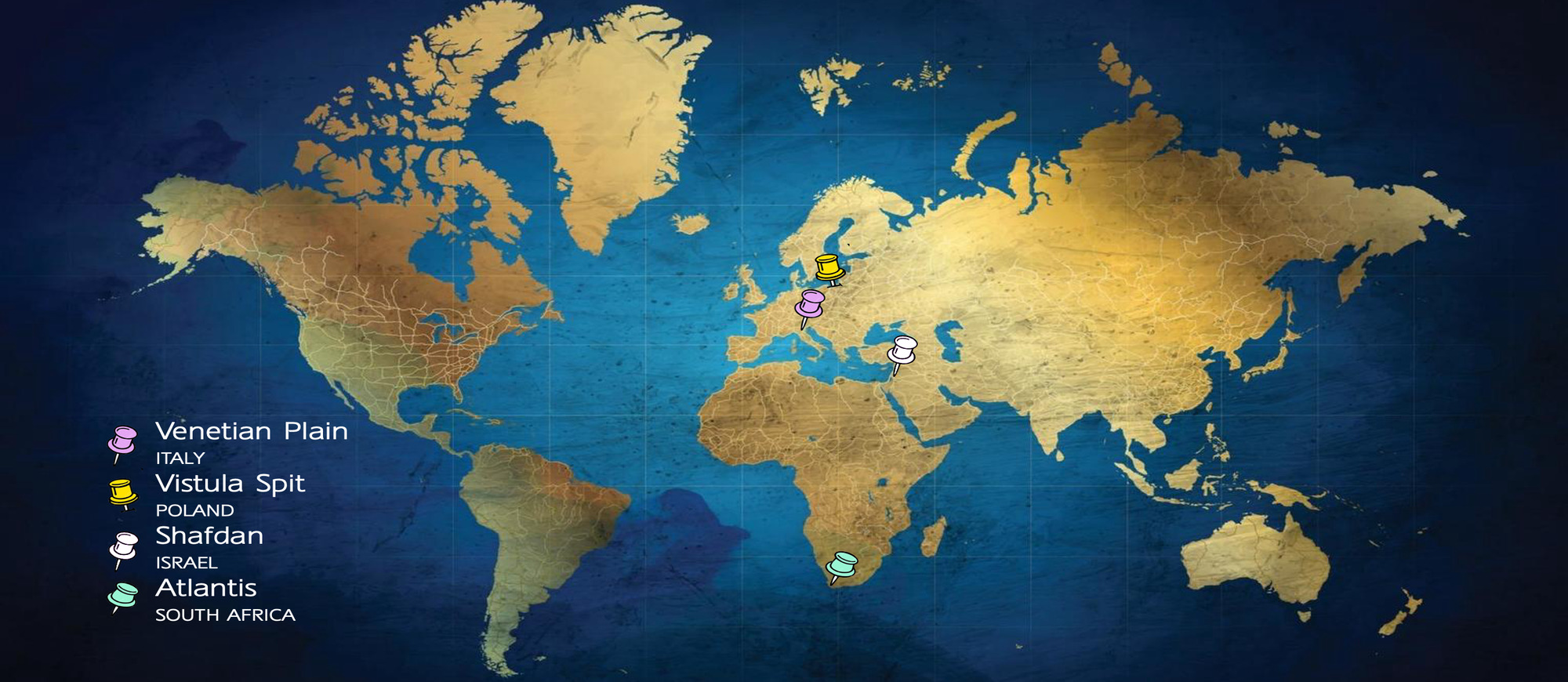
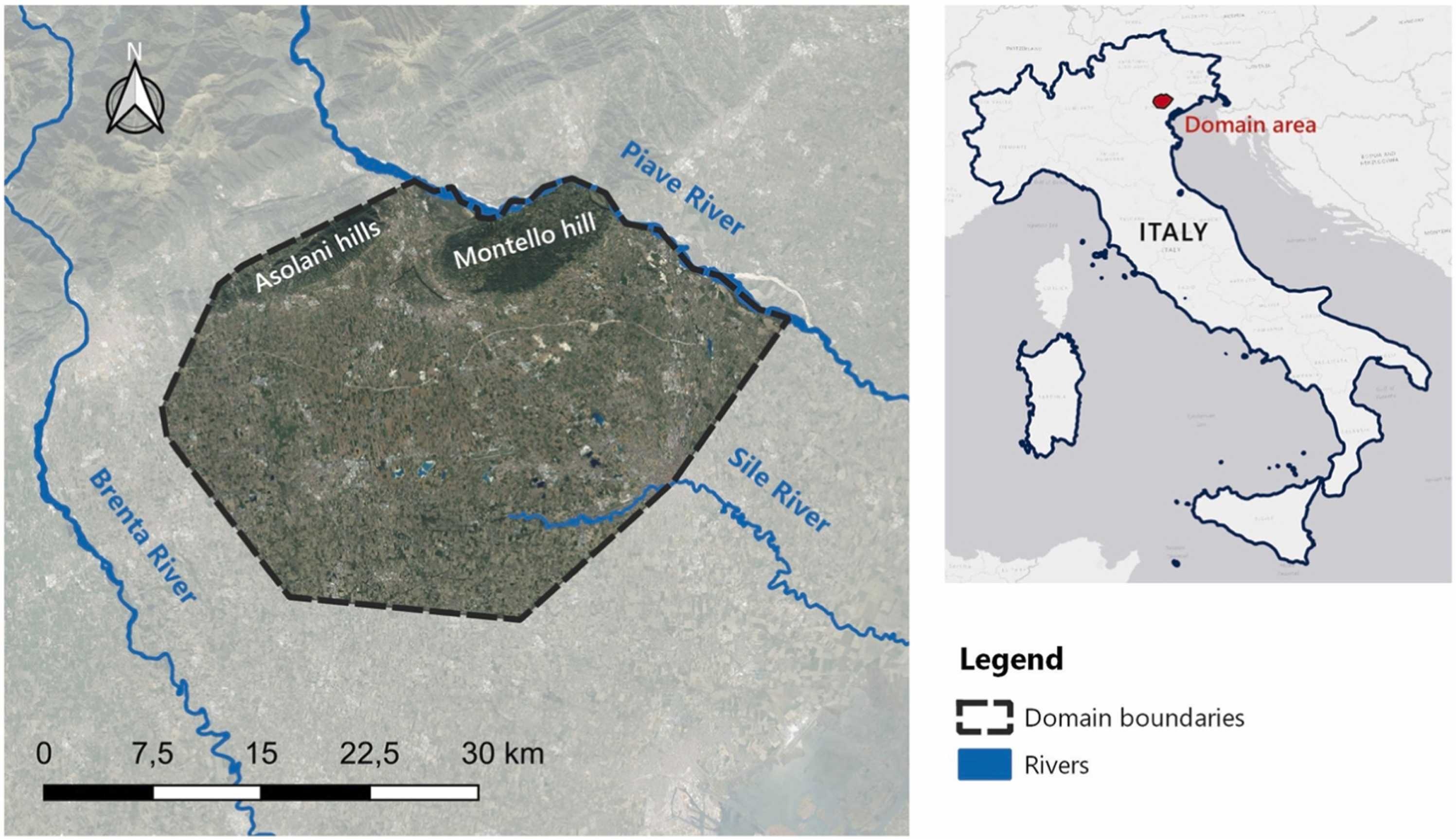
Venetian plain between the Brenta and Piave rivers (Italy)
This study area spans approximately 900 km² and is bounded by the Piave River to the northeast, the Brenta River to the west, the artesian "risorgive" zone to the south (where the Sile River and other minor groundwater-fed rivers originate), and the Montello Hill and Colli Asolani to the north.
This aquifer system consists of a deep unconfined aquifer that gradually transitions into a system of multilayer aquifers going from the mountains (NW) to the sea (SE). This groundwater system is characterized by high flow velocities (up to meters per day) and is mainly recharged in the piedmont zone through rainfall and irrigation.
This aquifer system supplies drinking water to over 800,000 people and the main land use is agriculture, dominated by grapevines, followed by cereals (mainly corn) and horticultural crops, making it a vital resource for both water supply and agriculture. Excess irrigation, historically conducted through the flooding system, has always represented a significant source of groundwater recharge. However, to comply with new EU regulations, flooding irrigation systems in the study area are being converted into sprinkler irrigation systems, with less water withdrawn from rivers, but potentially less groundwater recharge.
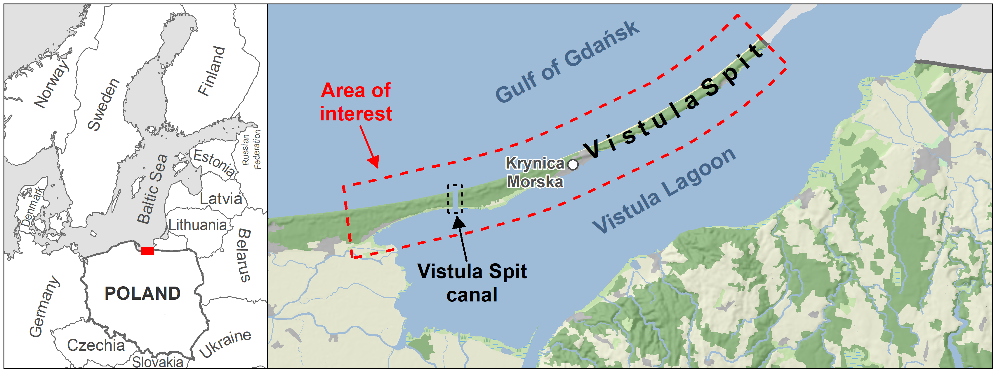
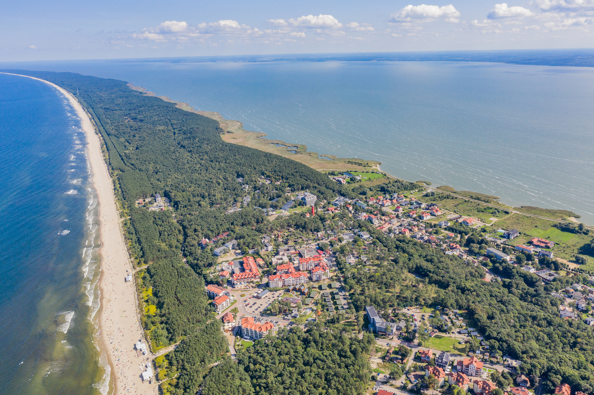
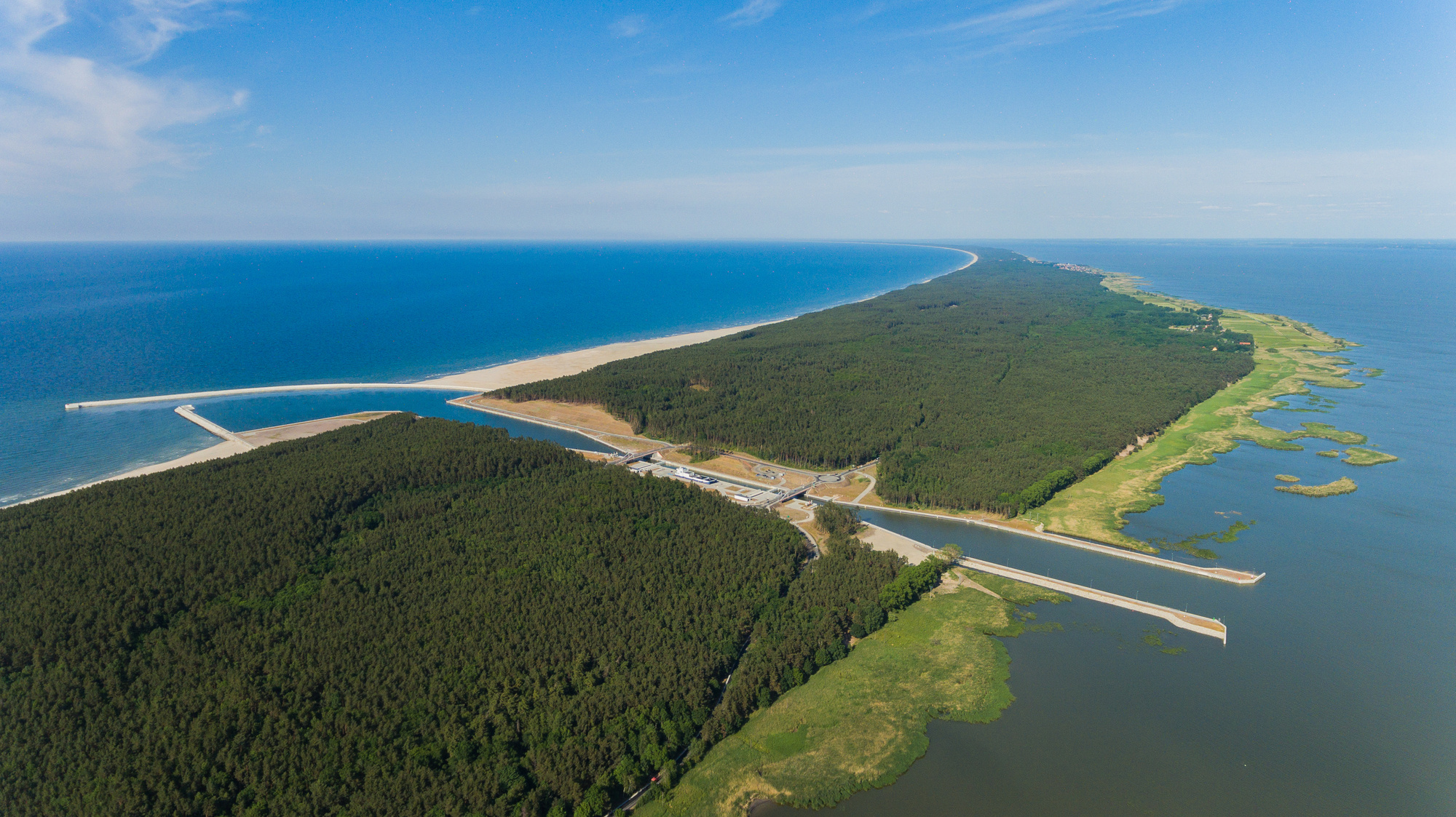
Vistula Spit (Poland)
The Vistula Spit is a long, narrow, sandy peninsula on the southern coast of the Baltic Sea, with total length of 73 km (Polish part). It stretches in a north-easterly direction and separates the Vistula Lagoon (brackish water, salinity 0.2-7‰, average 3‰) from the Gulf of Gdansk (salinity 7-8‰). The area is dominated by forest and the largest town is Krynica Morska with 1,284 inhabitants. The development of the Vistula Spit is associated with Holocene processes, which led to the creation of a well-developed system of dune ridges. The geologic setting of the study area is homogeneous, consisting of marine and aeolian sands, as well as peat formed locally as interdune peatbogs
The main source of water supply is a shallow, unconfined freshwater lens, laying on the low permeable sediments occurring about -40 m above sea level. The aquifer occurs in Pleistocene-Holocene sands and the thickness is about 40 m. The entire hydrosystem is recharged by precipitation and drained by the Baltic Sea (Gulf of Gdansk) and Vistula Lagoon. The depth to groundwater ranges from very small on the beaches to over 20 m under dunes in the central part of the spit. Locally in groundwater samples were noticed increased concentrations of ammonia (>1 mg/l), of natural origin.
Groundwater is used to supply Krynica Morska, with a large uptake in summer (high tourist season) which cause salinization. The temporal variability of groundwater exploitation resulted in a large variability of chloride concentration. At the Vistula Spit freshwater resources are extremely vulnerable to seawater intrusion, especially with unsustainable groundwater exploitation. Numerical simulations show that the freshwater/saltwater interface is very sensitive and easy to disturb due to overexploitation of groundwater.
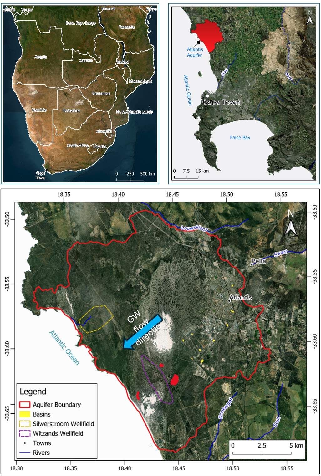
Atlantis (South Africa)
The Atlantis Aquifer is located in the west coast of South Africa, about 50 km north of the city of Cape Town, in the town of Atlantis. The Aquifer is an integral part of the Atlantis Water Resource Management Scheme, augmenting surface water supplies to the town of about 67 000 residents. Atlantis experiences a Mediterranean climate with hot, dry summers and mild, wet winters, with a prevailing southerly wind direction.
The geology of the aquifer is characterised by unconsolidated late Paleogene to Quaternary aged marine and aeolian interbedded sands, clay, sandstone, limestone, coarse gravels and peats of the Sandveld Group, which overlie the Malmesbury Group and Cape Granite Suite basement rocks. The primary, unconfined aquifer covers an area of about 130 km² and ranges in thickness from 0 to 80 m, with groundwater generally flowing southwest towards the Atlantic Ocean. The aquifer is primarily recharged by precipitation. However, to augment natural recharge, managed aquifer recharge (MAR) is practised using all domestic stormwater generated from the town, most of the industrial stormwater and all the treated domestic effluent. There are two abstraction wellfields at the site - the Silwerstroom Wellfield and the Witzands Wellfield, the latter of which is artificially recharged via two upgradient infiltration basins. Poorer-quality industrial effluent and stormwater from the noxious trade area are diverted to coastal recharge basins and discharge into the ocean. Groundwater abstracted from the Witzands Wellfield is softened, blended with surface water from the Voëlvlei Dam, is disinfected and supplied to Atlantis via the Pella Reservoir, while groundwater from the Silwerstroom Wellfield is filtered, disinfected and distributed through the Hospital Reservoir.
The scheme has been undergoing expansion and refurbishment since 2019, following the severe "Day Zero" drought that affected Cape Town between 2015 and 2018. The expansion and refurbishment include re-drilling of production boreholes, drilling of monitoring boreholes to expand the monitoring network, rehabilitation of production boreholes to increase yield, as well as upgrading of wellfield and MAR infrastructure.
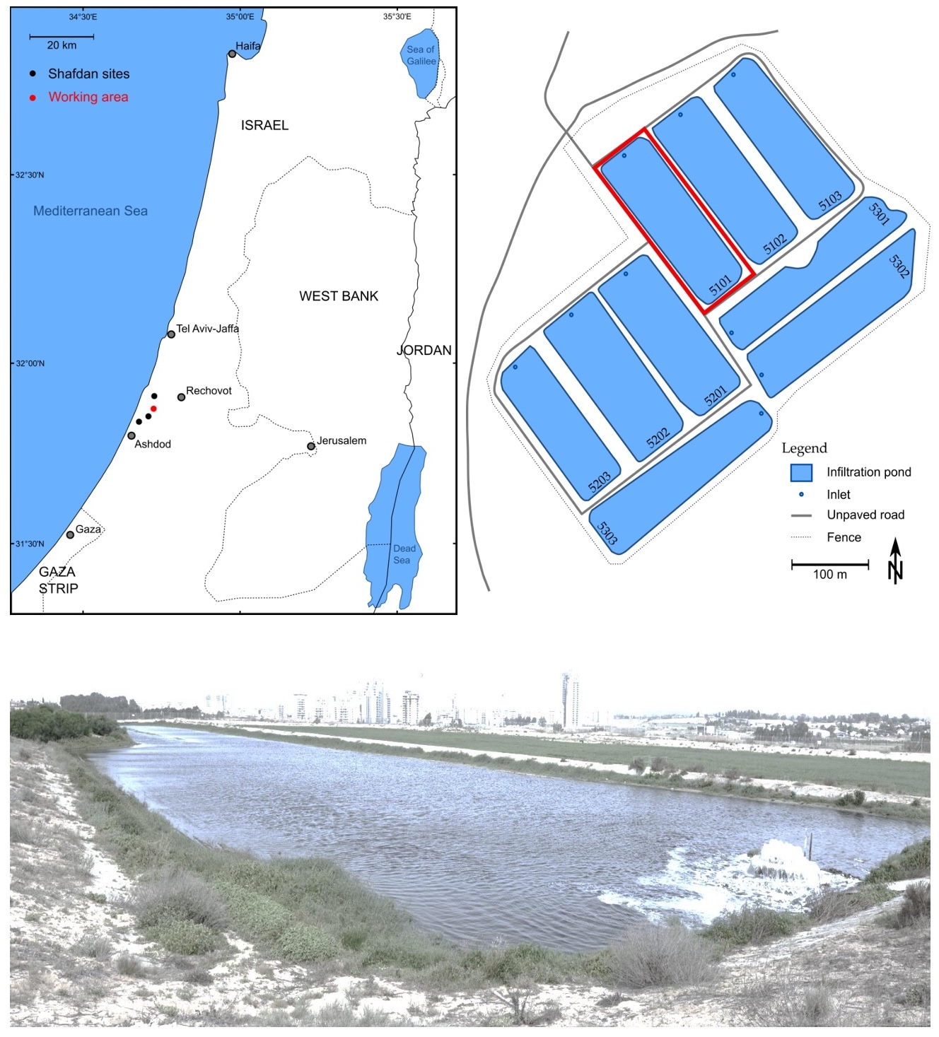
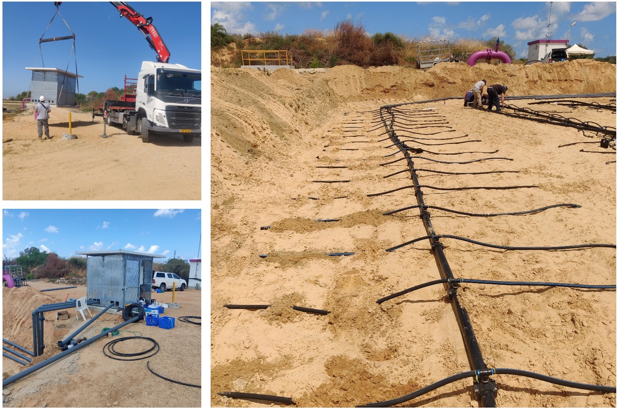
The SHAFDAN facility (Israel)
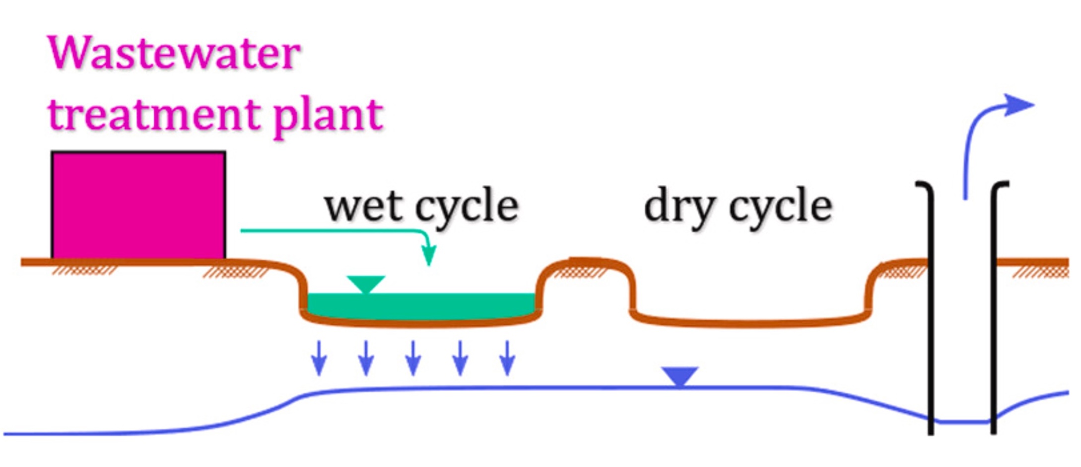
The Dan Region Reclamation Project (Shafdan) reclaims about 125 million m³ of effluent annually from Israel's Tel Aviv metropolitan area. The treatment of effluents occurs in two stages. The first stage involves "conventional" mechanical biological treatment based on activated sludge. In contrast, in the second stage, the treated water (a secondary effluent) is delivered to infiltration basins as part of the SAT system to improve water quality further. The six infiltration basin sites, covering a total area of 1.053 km², are located in central Israel, overlying the coastal aquifer. Each basin is divided into several spreading ponds, about 1500 m² each, alternately flooded. This flooding and drying scheme is needed to sustain aerobic conditions in the upper vadose zone (~1 m). The vadose zone underlies the basins, which mainly comprise sand, sandy loam soil, and calcareous sandstone layers. Typically, the ponds are flooded for 1 to 2 days (with a maximum hydraulic head of about 50 cm), followed by 2 to 6 days of drainage and soil surface drying. The basin surface is ploughed regularly to break up the developed biocrust and to prevent clogging.
Our experimental site is located at the Yavne 2 basin. It includes various sensors buried in the soil at depths of 80-120 cm, including water content, temperature, and ORP. Additionally, porous plates are also buried for sampling of liquids. In addition, a unique aeration system was designed and buried at depth of 1 m below ground. This system generates air bubbles, potentially allowing alternative mean of aeration. This system covers about 600 m² of the research pond.
METHODS
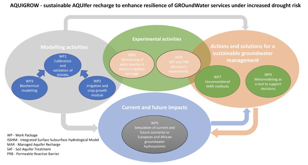
The general concept of the project is shown in the figure below, which summarizes the different methods (organized in 8 work packages, WPs) and highlights the strong interactions and intersections among them.
To achieve the goals, we plan to use a combination of modeling (WPs 1-5) and experimental activities (WPs 6-8), complemented by operational but innovative research tasks aimed at suggesting solutions for a sustainable groundwater management and prediction of current and future impacts of land use change and climate change in European and African groundwater hydrosystems.
The developed approaches will be demonstrated and validated on sites in Italy, Poland, South Africa, and Israel, where we will work in close collaboration with water management agencies and other stakeholders.
WP1 - Calibration and validation of a suite of integrated surface-subsurface hydrological models
The use of Integrated Surface-Subsurface Hydrological Models (ISSHMs) is essential for calculating how groundwater recharge varies over time and space, based on inputs like rainfall, evaporation, and irrigation. Simulations will be carried out for the AQUIGROW project sites using two advanced hydrology models: CATHY (CATchment HYdrology) for sites in Italy and South Africa, and HydroGeoSphere (HGS) for the site in Poland.
Both models simulate water movement in 3D, solving the Richards equation for groundwater flow and the shallow water equation for surface water. HGS also accounts for density-driven groundwater flow, which is particularly relevant to conditions in Poland. These models will provide detailed insights into how rainfall and irrigation water are divided between infiltration into the ground and surface runoff.
The findings from these simulations will be used to refine and validate a decision-support system, which will integrate the MODFLOW groundwater model with HYDRUS-1D to simulate water and solute movement through different soil types, representing both natural and artificial recharge scenarios.
WP2 - Implementation of state-of-the-art irrigation and crop growth modules in ISSHMs
Irrigation and crop water needs play a significant role in water use, so the ISSHMs will incorporate various irrigation methods (e.g., drip, sprinkler, and flood irrigation). These models will be enhanced to better simulate the growth and water needs of crops, thanks to data from the European Space Agency's Copernicus Sentinel satellites. This Earth Observation data includes soil moisture, evapotranspiration, vegetation dynamics, and satellite-based irrigation estimates. It will be used to refine model parameters and improve predictions of water use and crop processes.
Key tasks include analyzing high-resolution satellite data ( < 1 km) to monitor evaporation, soil moisture, and vegetation growth. This data will inform irrigation estimates and validate the models' predictions of crop water use, evapotranspiration, and soil moisture. Advanced techniques combining microwave and optical satellite observations will help quantify irrigation more accurately.
The goal is to integrate crop simulation models (with irrigation modules) and hydrological models (e.g., CATHY, MODFLOW/HYDRUS-1D) to improve predictions of crop water needs and their impact on the water cycle. This agro-hydrological modeling approach will provide more accurate estimates of irrigation requirements and water balance components, addressing gaps in current large-scale models.
WP3 - Biochemical modeling
In Israel, soil aquifer treatment (SAT), a form of managed aquifer recharge (MAR), has been used for decades to produce high-quality water for irrigation. However, land scarcity is increasingly limiting its application. A new approach suggests using agricultural fields as a temporary means of groundwater recharge. This research will explore this idea further, defining its agronomic and biochemical boundaries and assessing its geographic and economic potential.
A biochemical model will be developed to support SAT site identification. This model will simulate water flow, nutrient and oxygen transport, and microbial processes using advanced reactive transport modeling. Key features include incorporating root uptake and extending the model to 2D/3D to analyze biochemical effects in orchard subplots.
The model will be built on a platform that integrates water flow and geochemical processes, simulating water movement, solute transport, and microbial dynamics. Calibration will occur in two stages: first for hydraulics and then for biochemical parameters, using data from field and laboratory experiments. Additional validation will use field data from sites in South Africa and Italy.
WP4 - Metamodeling as a tool to support decisions
Physics-based models for water and pollutant movement are complex, requiring extensive data and computation. To make these tools more accessible and efficient for decision-making, this work package focuses on metamodeling (simplified surrogate models). Using methods like Gaussian Processes (GP) and machine learning, simplified models will predict outcomes with fewer inputs while managing uncertainties. These metamodels will reduce computational demands and carbon footprint, making them more practical for non-experts.
In this project, surrogate models of ISSHMs will be developed using various methods (e.g., deep learning, random forests, Gaussian processes) and evaluated based on accuracy, computational efficiency, and ability to capture uncertainties. The main goal is to identify the best approach to simplify the model while maintaining reliability. Surrogate models will also simplify other hydrological models, such as MODFLOW and HYDRUS, particularly for predicting groundwater recharge. By replacing the more computationally intensive HYDRUS-1D with a surrogate model, stakeholders can more easily use these tools without requiring specialized expertise. Ultimately, this research aims to make advanced water management models faster, simpler, and more accessible for decision-making, while minimizing computational costs and environmental impact.
WP5 - Simulation of current and future scenarios in European and African groundwater systems
he tools developed will be applied to groundwater systems in Europe and Africa. The goal is to understand current recharge patterns and predict future changes due to land use and climate shifts. Using advanced climate models and scenarios, we will assess impacts over the next 25-75 years, including drought risks and shifts in irrigation methods.
In Italy, we will simulate how transitioning from surface irrigation to sprinklers might reduce groundwater recharge. For Poland, we'll analyze groundwater and solute transport, exploring the role of Managed Aquifer Recharge (MAR) in mitigating climate impacts. In South Africa, we'll optimize MAR and Permeable Reactive Barrier (PRB) systems to improve water quality and recharge under future scenarios.
WP6 - Monitoring of water quality in excess-irrigation recharge
Pilot sites in Italy will be monitored for groundwater contamination caused by irrigation. Advanced chemical analyses will identify and track hazardous pollutants, such as pesticides from vineyards. Data from these studies will be used to validate models and assess the environmental risks associated to changing recharge patterns.
WP7 - Unconventional MAR methods
The AQUIGROW project aims to develop affordable ways to clean treated wastewater and stormwater so they can be safely reused to replenish underground water supplies. The approach combines Managed Aquifer Recharge (MAR)- injecting treated water into the ground- with Permeable Reactive Barriers (PRBs), which are filters made from materials like iron turning waste, activated charcoal, or woodchips to improve water quality. This method could help water-scarce countries manage their groundwater more effectively.
A pilot system will be tested in South Africa's Cape Flats or Atlantis Aquifers and on a smaller scale in Israel. Treated wastewater and stormwater will be tested for pollutants like pharmaceuticals, personal care products, pesticides, and PFAS (persistent chemicals often used in everyday items).
The project will study how these pollutants spread, break down, or persist in the environment. Data from lab and field experiments will help create models to predict how these pollutants move and change over time. This will ensure safe, long-term use of treated wastewater and stormwater for replenishing aquifers and protecting drinking water sources.
WP8 - SAT and PRB laboratory experiments
Even before testing SAT (Soil Aquifer Treatment) and PRB (Permeable Reactive Barrier) systems in real-world locations, small-scale experiments will be conducted in a lab to study how well these methods clean treated wastewater. A specialized soil chamber will measure infiltration rates, clogging, pollutant removal, and greenhouse gas emissions. Reactive materials such as tuff, coal, and biochar will be tested for their ability to improve water quality.
PUBLICATIONS
- Lambert, G., Helbert, C. & Lauvernet, C. Quantization-Based Latin Hypercube Sampling for Dependent Inputs With an Application to Sensitivity Analysis of Environmental Models. Appl Stochastic Models Bus Ind (2025)
https://doi.org/10.1002/asmb.2899 - Gumuła-Kawęcka, A., Jaworska-Szulc, B. & Jefimow, M. Climate change impact on groundwater resources in sandbar aquifers in southern Baltic coast.Sci Rep 14, 11828 (2024).
https://doi.org/10.1038/s41598-024-62522-0 - Oad, V. K., Szymkiewicz, A., Berezowski, T., Gumuła-Kawęcka, A., Šimůnek, J., Jaworska-Szulc, B., & Therrien, R. (2025). Incorporation of Horizontal Aquifer Flow into a Vertical Vadose Zone Model to Simulate Natural Groundwater Table Fluctuations. Water, 17(14), 2046.
https://doi.org/10.3390/w17142046 - Camporese, M., Paniconi, C., & Putti, M. (2025). Computing groundwater recharge and saturated storage dynamics: A Richards equation-based recipe. Water Resources Research, 61, e2025WR039997.
https://doi.org/10.1029/2025WR039997
NEWS
- 24-09-2025 - AQUIGROW researchers interviewed
Two AQUIGROW researchers - Matteo Camporese and Christian Massari - have been interviewed by Italian media to discuss the project’s potential impact and, more broadly, strategies to protect groundwater resources.
Read the interviews (in Italian):
Servizi a Rete, July/August 2025, p. 139 (interview with M. Camporese)
la Voce, 21 September 2025, p. 6 (interview with C. Massari) - 29-09-2025 - AQUIGROW at the 3rd OZCAR TERENO conference
AQUIGROW’s researchers will participate in the 3rd OZCAR TERENO conference, taking place in Paris from Monday, 29 September to Thursday, 2 October 2025.
This international conference, now in its third edition, is part of a biennial series jointly organized by the French Critical Zone Observatory network (OZCAR) and the German Terrestrial Environmental Observatories (TERENO). Alternating between France and Germany, the event serves as a key platform for advancing knowledge and fostering collaboration in hydrological and critical zone research.
We welcome the opportunity to connect with fellow participants. If you are attending and wish to arrange a meeting with our team, please do not hesitate to contact us. - 08-04-2025 - AQUIGROW at the EU Working Group on Groundwater
On 8 April 2025, Adam Szymkiewicz, PI of the GUT team, presented the AQUIGROW project during a meeting of the EU Working Group on Groundwater, which was held as a hybrid event in Warsaw and online. The meeting was organised by the Polish Ministry of Infrastructure in the framework of the Polish EU Presidency. - 21-02-2025 - AQUIGROW at ISMAR12
AQUIGROW's researchers will attend the 12th International Symposium on Managed Aquifer Recharge, which will be held in Stellenbosch (South Africa) from 28 April to 2 May 2025. If you are attending too and would like to meet us in person, please get in touch! - 15-11-2024 - Best presentation award at the 6th Southern African Development Community – Groundwater Management Institute conference
Ms. Maposholi Mokhethi, one of our research team members from Stellebosch University (South Africa), was presented by the Groundwater Management Institute with the best presenter award at the 6th SADC Groundwater Conference Young Professionals Competition. Congratulations!
CONTACTS
Please contact us at info@aquigrow.it